CIVIL & ENVIRONMENTAL CONSULTANTS PROJECTS
Indian Lake State Park – H2Ohio Green Infrastructure Project
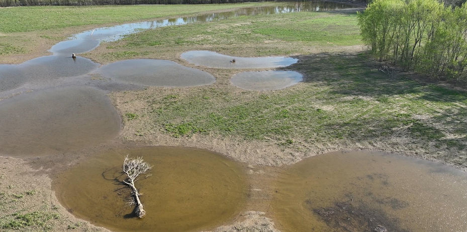
The Indian Lake Watershed Project (ILWP) and Civil & Environmental Consultants worked with the Ohio Department of Natural Resources (ODNR) H2Ohio Program to restore wetland detention, retain nutrients, and treat urban runoff within the Indian Lake State Park campground. The grant application was based upon identified potential project areas within the Indian Lake-Great Miami River HUC-12 Nonpoint Source-Implementation Strategy (NPS-IS), which was prepared by Civil & Environmental Consultants (CEC). In coordination with the ILWP and ODNR, CEC identified three locations within the campground to maximize stormwater management, detention, and nutrient removal through wetland restoration and creation activities. Approximately 3.5 acres of stormwater green infrastructure treatment wetlands were restored at these locations through microtopographic depressional grading and installation of water management control, such as weirs and concrete outfall structures.
Harroun Park River Trail Stream Restoration – Phase 1 and 2
Harroun Community Park encompasses approximately 1,400 linear feet of Tenmile Creek and North Tenmile Creek, and the beginning of the Ottawa River, within the City of Sylvania, Ohio. The approximate 135-square mile watershed is subject to intensive urbanization within the City of Sylvania limits and intensive agricultural land-use and drain tile in the headwaters. Land management in the watershed has resulted in intensive channel management and failure, including historic channel straightening, bank erosion, and lateral channel migration. The streambank failure threatened a public trail, and other areas of erosion were addressed with intensive use of rubble bank protection. These management techniques were implemented to address stream channel widening, and ongoing habitat loss from sediments inundation and nutrient blooms. The City engaged CEC in the pursuit of grant funds from Great Lakes Restoration Initiative subawards from both the Ohio Lake Erie Commission (2018) and the Ohio EPA (2022) for funding to restore the stream and protect critical infrastructure in the park.
Natural Channel Design methods were used to stabilize stream channel banks, in-channel habitat, including riffle construction, nine J-Hook structures, reinforced earth geo-lifts for stream bank restoration, live-brush layering, live-stake planting and native seed, root wads, and toe-wood. Field adjustments were made to avoid mature trees and their roots and bedrock shelves, and to stabilize highly erodible slopes adjacent to public infrastructure.
Scioto Bend Floodplain Replenishment Project
The Scioto Bend Floodplain Replenishment Project provided floodplain enhancement, water quality, and habitat restoration to an approximate 150-acre field that was annexed from the Scioto River by a 10-foot levee system. The project engaged different portions of the field at different storm event frequencies with about 65-80 acres re-engaged at a 0.9-year storm frequency elevation. These goals were accomplished by identifying areas for levee removal to allow additional floodwaters to access the floodplain, restore depressional wetland habitat to improve floodwater detention, improve wetland habitat and storage around the two open water features (where possible), install beaver dam analogs and low-profile earthen berms to promote water detention, and restore native vegetation back to the agricultural and industrially managed portions of the Site. This project was constructed for Appalachia Ohio Alliance (AOA) and funded in part by the State of Ohio Water Resource Restoration Sponsor Program (WRRSP) and private donations.
Dillon Reservoir - H2Ohio Wetland Treatment Train Project
Dillon Reservoir is a 1,560-acre U.S. Army Corps of Engineer (USACE) owned lake on the Licking River that straddles Licking and Muskingum Counties and was constructed in 1961 to address regional flood control. The Ohio Department of Natural Resources (ODNR) Division of Ohio State Parks and Watercraft (OSPW) and Division of Wildlife (DOW) manage approximately 8,200 acres of federally owned property around Dillon Reservoir for wildlife and recreational purposes. The recreation area and a majority of the lake are affected by harmful algal blooms sourced by high sediment runoff from the watershed containing fertilizers and nutrients resulting in closures, restrictions, dangerous water quality, and lake eutrophication.
To help address the sources of this nutrient loading, OSPW and their partners at Rural Action (RA) applied for funding through the H2Ohio program to remove approximately 100 acres of leased agricultural land from agricultural production within the flood management portions of the Dillon Lake Wildlife Management Area. The project area was selected in part for the size and ability to engage the groundwater table in the vicinity and to expand on existing high-quality habitat surrounding the fields. Agricultural ditching and natural resource roadway gutters within the Dillon Wildlife Management Area route natural landscape-level surface runoff from the vicinity around the project area, directly to the Licking River and the Reservoir. Those pathways were re-directed with low-profile earthen berms to manage that hydrology in the proposed wetland restoration area.
Sycamore State Park – In Lieu Fee Mitigation Bank
This 151-acre project provided compensatory wetland and stream mitigation to offset unavoidable impacts in the Lower Great Miami River watershed through The Nature Conservancy’s (TNC) Ohio Mitigation Program (OMP). The project removed approximately 100 acres from agricultural production and Civil & Environmental Consultants restored 8,500 LF of Type 1 Level 1 and 812 LF of Type 1 Level 4 stream mitigation, 53.9 acres of forested headwater wetland restoration, and approximately 93.7 acres of riparian buffer enhancement and restoration. Most of the stream restoration was re-establishing a new stream channel in a landscape managed with intense drain tile networks. Those drain tile networks were neutralized. Natural channel design was used and incorporated valley cutoff logs, rock cross vanes, rock constructed riffles, new channel establishment, floodplain grading, and toe wood. Approximately 9,800 live stakes were installed along the restored stream channels and 80,215 bare root trees were planted in the wetland, the riparian buffer, and upland areas. This project was designed by Civil & Environmental Consultants and planted by Williams Forestry & Associates.


